

Quick answer
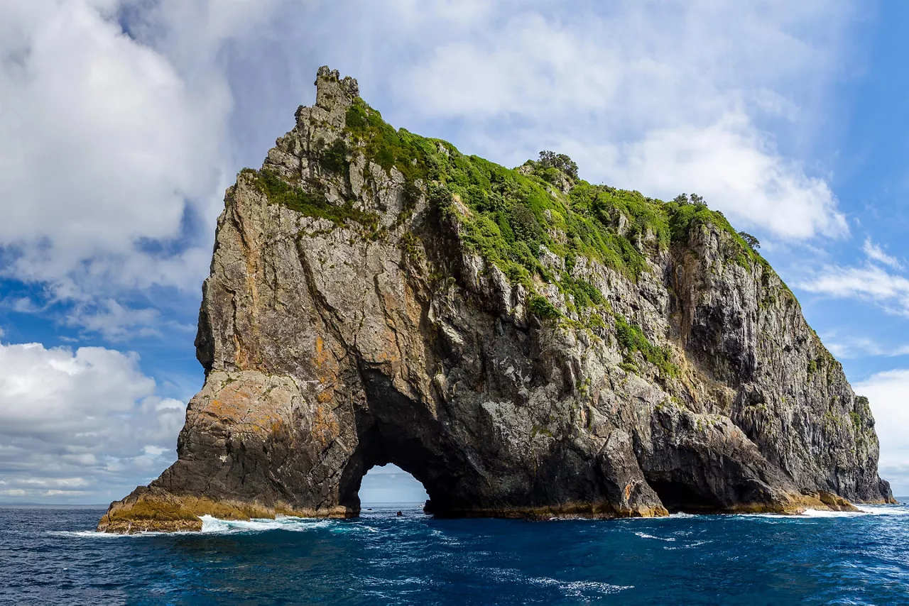
Hole in the Rock formed through millions of years of wave erosion carving through the basalt remnants of an extinct volcano at Cape Brett. Māori navigators named the island Motukōkako and wove it into oral tradition long before Captain Cook charted the Bay of Islands in 1769. The arch became a maritime landmark for European vessels navigating these waters throughout the 19th century, and tourism operations began running boats through the opening in the mid-20th century.
The basalt cliffs at Motukōkako Island were once part of a volcanic cone that erupted beneath the Pacific Ocean approximately 20 million years ago. Wave action carved the arch over geological time, creating an opening large enough for small vessels to pass through at calm tide. The island sits at the outer edge of Cape Brett, exposed to the full force of ocean swells that continue to shape its profile. Māori tradition records Motukōkako as a navigational reference point for waka traveling between the outer islands and sheltered harbors. The name itself references the rock's distinctive profile when approached from the open sea. Oral histories passed through Te Hikutu and Ngāpuhi iwi describe the island as a threshold between coastal waters and the deep Pacific, a boundary marked by seabirds and shifting currents. European contact brought new names and charts, but the island's role as a waypoint remained unchanged. Captain Cook's 1769 survey documented the rock as part of his Bay of Islands coastal mapping, though his vessels did not attempt passage through the arch. Subsequent maritime traffic—whalers, traders, and naval ships—used the formation as a bearing when making landfall. By the early 1900s, local knowledge of safe passage conditions had spread among small-boat operators, and the first recreational trips through the arch were recorded in the 1920s. Commercial tour operations formalized in the decades that followed, establishing the route that vessels follow today. The hole in the rock history is inseparable from the tidal and weather patterns that govern access. Early navigators timed their passages to avoid swell surge, a practice modern operators continue. The arch's clearance varies by several meters depending on tide height and sea state, and the decision to transit remains a judgment call informed by generations of accumulated seamanship. The landmark's endurance depends on the same forces that created it—erosion continues to widen the opening by millimeters each year, a process visible only across decades. Visitors approaching Motukōkako encounter the same geological and maritime context that shaped centuries of navigation. The rock stands as both a natural monument and a working feature of the seascape, its significance renewed with each careful passage.
“Wave action carved the arch over geological time, creating an opening large enough for small vessels to pass through at calm tide.”
The Geological and Cultural Hole In The Rock History
The natural arch known as Hole in the Rock stands at the tip of Motukōkako Island, shaped over millennia by the relentless action of Pacific swells against the porous volcanic rock. Wave erosion carved the tunnel through the headland, a process documented by geologists studying the Bay of Islands' basaltic formations since the early twentieth century. The arch measures approximately sixty metres in height and pierces clean through the promontory, creating a navigable passage that draws vessels from across the region. For the Ngāti Kuta and Patukeha hapū of the Bay of Islands, the formation carries deep cultural significance predating European contact. Traditional accounts name the site as a waypoint in ancestral voyaging routes, where navigators read tides and currents through the opening to judge safe passage. Captain James Cook charted Cape Brett during his 1769 survey of New Zealand's northeastern waters, noting the distinctive profile of the outer islands, though the arch itself received scant mention in his logs. Commercial interest arrived in the late nineteenth century when coastal traders began threading smaller craft through the opening during calm conditions. By the nineteen-thirties, local operators in Russell and Paihia offered occasional excursions to the arch, establishing the template for today's boat tours. The Department of Conservation assumed formal guardianship of the Cape Brett peninsula and its offshore islands in the nineteen-eighties, designating the waters around Motukōkako as part of a protected marine reserve to safeguard the endemic seabird colonies nesting on the cliffs. Visitors approaching the arch today witness the same geological profile Cook's crew observed, though modern GPS and weather monitoring have made passage far safer than in earlier centuries. The rock face still bears the marks of wave action, with fresh erosion visible along the tunnel walls where swells continue their slow work.
Volcanic activity forms the basaltic islands at Cape Brett, including Motukōkako Island.
Ngāti Kuta and Patukeha hapū navigate the waters around the arch, embedding the site in oral tradition and voyaging lore.
Captain James Cook charts Cape Brett during his first Pacific voyage, mapping the Bay of Islands' outer coastline.
Coastal traders and fishing vessels begin using the arch as a passage during favourable sea conditions.
Tourism operators in Russell and Paihia launch the first organised boat excursions through Hole in the Rock.
Department of Conservation establishes marine protection around Cape Brett, including the waters surrounding Motukōkako Island.
Interesting Facts About Hole In The Rock History
The Hole in the Rock, known locally as Motukōkako, holds deep cultural and historical significance beyond its geological formation. These points detail its status within local Māori tradition and European exploration history.
Motukōkako Name Origin
The name Motukōkako refers to the island being a former habitat for the kōkako bird, a species now rarely seen in the region. The island is also referred to as Piercy Island by European explorers.
Tapu Status
Motukōkako is a tapu site, meaning it is sacred under Māori tradition and holds spiritual significance for local iwi, Ngāti Kuta and Patukeha. Access to the island surface is restricted to respect its cultural importance.
Captain Cook's Naming
Captain James Cook named the island Piercy Island during his 1769 voyage in the HMS Endeavour. He named it in honor of the Lords of the Admiralty at the time.
16-Meter High Archway
The signature hole was created by centuries of marine erosion and wave action against the island's rock face. The archway stands approximately 16 meters high at its peak.
Archaeological Findings
Evidence of historical Māori occupation has been documented on the island, reflecting its strategic importance for surveillance and fishing in the Bay of Islands. The island's geography provided a natural defensive position.
Geological Composition
The island consists primarily of volcanic rock formations resulting from underwater eruptions millions of years ago. These layers have been sculpted by the Pacific Ocean into the iconic landmark visible today.
Best Arrival Window for Hole In The Rock History Tours
The best arrival window for visiting the Hole in the Rock at Motukōkako Island is between 08:30–14:00. This timeframe provides the most reliable sea conditions for boat passage and optimal natural light for photography.
Summer (Dec–Feb)
High volume; advance booking essentialWarm, 20°C–25°C; stable sea conditions
High temperatures and calm waters favor maritime excursions. Long daylight hours allow for flexible scheduling within the daily window.
Autumn (Mar–May)
Moderate volume; consistent weatherMild, 15°C–20°C; clear visibility
Sea conditions remain favorable for boat transit. Photographers benefit from softer light during the morning hours.
Winter (Jun–Aug)
Low volume; variable sea statesCool, 10°C–15°C; occasional swells
Excursions are subject to weather conditions. The morning window provides the best opportunity for calm waters before afternoon winds.
Weekday mornings
Lower volume; relaxed pace—
Visiting between 08:30 and 11:00 often avoids the peak surge of afternoon cruise traffic. This period offers quieter conditions for viewing the landmark.
Verdict: The optimal period to visit is during the shoulder months of March to May or September to November, arriving between 08:30 and 11:00 on weekdays.
Admission Fees and Hole In The Rock History Access
Access to the Hole in the Rock natural landmark is free of charge. Costs are only incurred when engaging private boat tour operators for transit to and close passage through the archway.
While the landmark is free to access, travelers typically pay variable rates to private boat operators for excursion services depending on the tour provider selected.
Logistics for Visiting the Site of Hole In The Rock History
The Hole in the Rock is located at Motukōkako Island, Cape Brett, in the Bay of Islands, New Zealand. Access to this natural landmark is exclusively available via sea-based transport from mainland departure points such as Paihia or Russell.
Departure from Paihia Wharf
Departure from Russell Wharf
Travel to Paihia or Russell via State Highway 11
Operational Hours Related to Hole In The Rock History
The Hole in the Rock is a natural landmark located at Motukōkako Island and is accessible throughout the week. Visitors should note that specific vessel access depends on sea conditions.
| Monday | 00:00–23:59 | |
|---|---|---|
| Tuesday | 00:00–23:59 | |
| Wednesday | 00:00–23:59 | |
| Thursday | 00:00–23:59 | |
| Friday | 00:00–23:59 | |
| Saturday | 00:00–23:59 | |
| Sunday | 00:00–23:59 |
Check availability
Common questions about hole in the rock history
Everything you need to know about hole in the rock history